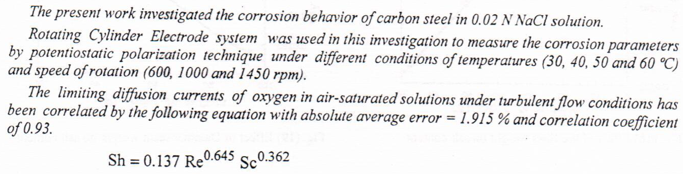
Effect of Velocity and Temperature on Mass Transfer of Oxygen in Corrosion Processes

The most significant function in oil exploration is determining the reservoir facies, which are based mostly on the primary features of rocks. Porosity, water saturation, and shale volume as well as sonic log and Bulk density are the types of input data utilized in Interactive Petrophysics software to compute rock facies. These data are used to create 15 clusters and four groups of rock facies. Furthermore, the accurate matching between core and well-log data is established by the neural network technique. In the current study, to evaluate the applicability of the cluster analysis approach, the result of rock facies from 29 wells derived from cluster analysis were utilized to redistribute the petrophysical properties for six units of Mishri
... Show MoreWe present a simple model of charge transfer current through sensitizer N3 molecule contact to TiO2 and ZnO semiconductors to calculate the charge transfer current. The model underlying depends on the fundamental parameters of the charge transfer reaction and it is based on the quantum transition theory approach. A transition energy, driving energy and potential barrier have been taken into account charge transfer current at N3 / TiO2 and N3 / ZnO devices with wide polarity solvents Acetic acid, 2-Methoxyethanol, 1-Butanol, Methyl alcohol, chloroform, N,N-Dimethylacetamide and Ethyl alcohol via the quantum donor-acceptor system.The effects of the transition energy and potential barrier are computed and discussion on charge transfer current.
... Show More

(3) (PDF) Theoretical investigation of charge transfer at N3 sensitized molecule dye contact with TiO2 and ZnO semiconductor. Available from: https://www.researchgate.net/publication/362773606_Theoretical_investigation_of_charge_transfer_at_N3_sensitized_molecule_dye_contact_with_TiO2_and_ZnO_semiconductor [accessed May 01 2023].
The effect of nitrogen fertilizer and the planting distance on growth and yield of the sunflower cultivar (Taka) was investigated. The experiment was conducted in the field using five nitrogen fertilizer levels (0, 50, 100, 150, 200) kg/donum and three planting distances (10, 20, 30) cm/plant. The experiment design was split-plot by using RCBD with four replicates. The level of fertilizer as the main plot, while the planting distance as the sub plot. Plant high and yield components were measured. Results indicated that using 200 kg/donum of nitrogen and 30 cm/plant of planting distance gave the highest rate of 1000 seeds weight and the number of seeds/ head. While using 200 kg/donum of nitrogen fertilizer with 10 cm/plant of planting dista
... Show More (1)
(1)
The transfer of training process occupies a great importance in achieving the ultimate goal of participating in the training programs , it is sure that this does not take place without the support of the working environment for trainees, and The research aims to personification role the work environment characteristics of supporting the transfer of training.
The research problem is the weakness transfer of training to the work en
... Show More
م.د. فاطمة حميد ،أ.م.د وفاء صباح محمد الخفاجي, International Journal of Psychosocial Rehabilitation,, 2020 - Cited by 1
In cooling water systems, cooling towers play a critical role in removing heat from the water. Cooling water systems are commonly used in industry to dispose the waste heat. An upward spray cooling water systems was especially designed and investigated in this work. The effect of two nanofluids (Al2O3/ water, black carbon /water) on velocity and temperature distributions along reverse spray cooling tower at various concentrations (0.02, 0.08, 0.1, 0.15, and 0.2 wt.%) were investigated, beside the effect of the inlet water temperature (35 ,40, and 45 ͦ C) and water to air flow ratio (L/G) of 0.5, 0.75, and 1. The best thermal performance was found when the working solution contained 0.1 wt.% for each of Al2
... Show More
(1)
(5)
This study investigates the changes occurring in the province of Basra using geospatial methods and analyzes the variations in land surface temperature among the various types of land cover. For the months of July and December in the years 2013 and 2021, Landsat images were used in Landsat 8 OLI/TIRS, and satellite images were processed using ArcGIS 10.8 software. The study's categories for land use and land cover were generated through the application of supervised classification techniques, and the land surface temperature was calculated using data from a satellite sensor's brightness temperature. According to the study's findings, there has been an increase in urban areas (including barren land). From 2013 to 2021, a greater correlati
... Show More
(3)