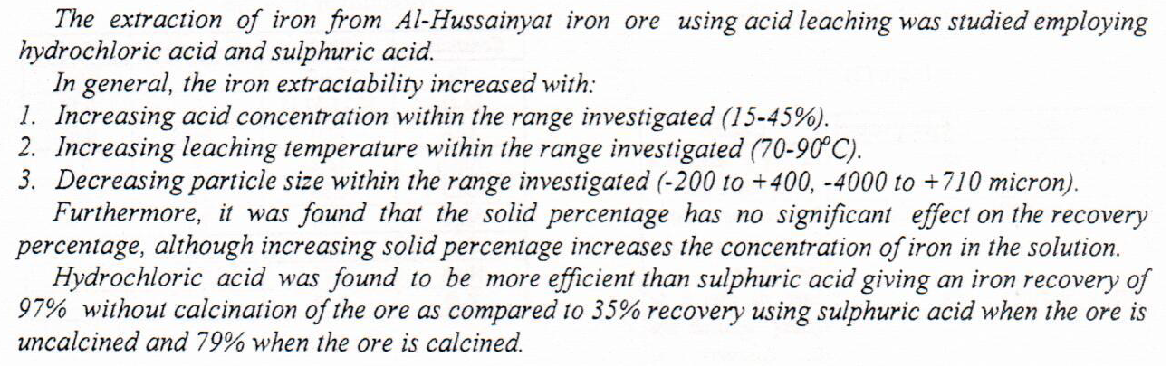
Extraction of Iron from Al-Hussainyat Iron Ore using Acid Leaching
This study has applied the theoretical framework of conceptual metaphor theory to the analysis of the source and target domains of metaphors that are used in two English nineteenth century sonnets, both written by contemporaneous female poets. The quantitative and qualitative results of the textual analysis have clearly revealed that Elizabeth Barrett Browning’s sonnet 23 centres around the conceptual mapping of the journey of love and life with that of possession. In contrast, Christina Rossetti’s sonnet Remember tackles the central conceptual mapping of death as a journey in relation to its further experiential connections. In addition, the application of conceptual metaphor theory in identifying the frequencies and densities of metap
... Show MoreThe current research creates an overall relative analysis concerning the estimation of Meixner process parameters via the wavelet packet transform. Of noteworthy presentation relevance, it compares the moment method and the wavelet packet estimator for the four parameters of the Meixner process. In this paper, the research focuses on finding the best threshold value using the square root log and modified square root log methods with the wavelet packets in the presence of noise to enhance the efficiency and effectiveness of the denoising process for the financial asset market signal. In this regard, a simulation study compares the performance of moment estimation and wavelet packets for different sample sizes. The results show that wavelet p
... Show MoreThe assessment of data quality from different sources can be considered as a key challenge in supporting effective geospatial data integration and promoting collaboration in mapping projects. This paper presents a methodology for assessing positional and shape quality for authoritative large-scale data, such as Ordnance Survey (OS) UK data and General Directorate for Survey (GDS) Iraq data, and Volunteered Geographic Information (VGI), such as OpenStreetMap (OSM) data, with the intention of assessing possible integration. It is based on the measurement of discrepancies among the datasets, addressing positional accuracy and shape fidelity, using standard procedures and also directional statistics. Line feature comparison has been und
... Show MoreUranium concentrations in soil were determined for ten locations in Salahdin governorate using CR-39 track detector, fission fragments track technique was used, the nuclear reaction of nuclear fission fragments obtained by the bombardment of 235U with thermal neutrons from (Am-Be) neutron source with flux (5000n.cm-2.s-1), the concentration values were calculated by a comparison with standard samples. The results of the measurements show that the uranium concentration in soil samples various from 0.42±0.018ppm in Beji province to 0.2±0.014 ppm in Tooz province with an average (0.31±0.08ppm), the values of uranium concentration in all samples are within the permissible limits universally.